NOTICE: PhillyWatersheds.org has been archived.

The archive will be available at http://archive.phillywatersheds.org for approximately one year (through September 2020). If you use or are responsible for content here that is not yet available elsewhere, please contact the PWD Digital Team.

Maps

  • strict warning: Non-static method view::load() should not be called statically in /jet/app/www/default/sites/all/modules/views/views.module on line 906.
  • strict warning: Declaration of views_handler_argument::init() should be compatible with views_handler::init(&$view, $options) in /jet/app/www/default/sites/all/modules/views/handlers/views_handler_argument.inc on line 0.
  • strict warning: Declaration of views_handler_filter::options_validate() should be compatible with views_handler::options_validate($form, &$form_state) in /jet/app/www/default/sites/all/modules/views/handlers/views_handler_filter.inc on line 0.
  • strict warning: Declaration of views_handler_filter::options_submit() should be compatible with views_handler::options_submit($form, &$form_state) in /jet/app/www/default/sites/all/modules/views/handlers/views_handler_filter.inc on line 0.
  • strict warning: Declaration of views_handler_filter_node_status::operator_form() should be compatible with views_handler_filter::operator_form(&$form, &$form_state) in /jet/app/www/default/sites/all/modules/views/modules/node/views_handler_filter_node_status.inc on line 0.
  • strict warning: Non-static method view::load() should not be called statically in /jet/app/www/default/sites/all/modules/views/views.module on line 906.
  • strict warning: Declaration of views_plugin_style_default::options() should be compatible with views_object::options() in /jet/app/www/default/sites/all/modules/views/plugins/views_plugin_style_default.inc on line 0.
  • strict warning: Declaration of views_plugin_row::options_validate() should be compatible with views_plugin::options_validate(&$form, &$form_state) in /jet/app/www/default/sites/all/modules/views/plugins/views_plugin_row.inc on line 0.
  • strict warning: Declaration of views_plugin_row::options_submit() should be compatible with views_plugin::options_submit(&$form, &$form_state) in /jet/app/www/default/sites/all/modules/views/plugins/views_plugin_row.inc on line 0.

The Big Green Map Gets An Upgrade

posted in

The Big Green Map is now bigger, greener and ... mappier. The Philadelphia Water Department is working all around the city to implement green stormwater infrastructure such as porous paving, stormwater tree trenches and rain gardens, just to name a few. Check out our interactive, up-to-date Big Green Map to find out where PWD has either completed construction on a project or has one in the design phase. Each of these projects is a tool in preventing runoff from overburdening Philadelphia's sewer system and keeping our rivers and streams clean by preventing combined sewer overflows.

In all, there are nearly 200 green infrastructure projects either completed or in design—be sure to zoom in on the map to see all the points appear in a given area, navigate the right-hand menu to view specific project types, and click on the green dots for more information on each project and a link to more information.

Urban What? Urban Forest!

posted in

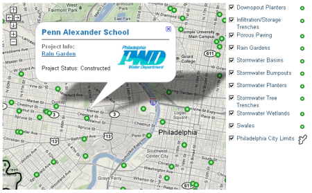
What is an urban forest? It's the collection of trees that grow in an urban area. Urban tree canopy is important for both environmental and economic reasons, as it reduces stormwater runoff, improves air quality and raises property values. Philadelphia has an estimated 2.1 million trees, with canopy covering 15.7% of the city. Tree density amounts to roughly 25 trees per acre, which is comparable to tree density in other American cities such as San Francisco (22.5) and New York (26.4)

Recently, Philly Tree Map was launched to help build an inventory of the trees that make up the Philadelphia’s urban forest. This project is a result of a partnership between the City of Philadelphia, Delaware Valley Regional Planning Commission  and the Pennsylvania Horticultural Society (PHS). Anyone can register for a free account to begin adding information to the database. Philly Tree Map uses a wiki-based structure that allows registered users to add data pertaining to tree size and species. Reliable users gain reputation points that add up to enable access to higher-level editing features. If you're not sure where to start, the FAQ section provides information on tree identification and measuring techniques. Also, this interview with Casey Combs of PHS offers insight to the development of project and its potential future uses.

The Big Green Map

posted in

The mayor's goal of transforming Philadelphia into America's greenest city is happening one project at a time. With PWD's Big Green Map, you can now locate and learn about our green infrastructure projects—from rain gardens and tree trenches to porous paving and downspout planters—in your neighborhood and around the city.

You'll need Google Earth to view this map. Download and install it here.

Syndicate content