NOTICE: PhillyWatersheds.org has been archived.

The archive will be available at http://archive.phillywatersheds.org for approximately one year (through September 2020). If you use or are responsible for content here that is not yet available elsewhere, please contact the PWD Digital Team.

Adam Levine

  • strict warning: Non-static method view::load() should not be called statically in /jet/app/www/default/sites/all/modules/views/views.module on line 906.
  • strict warning: Declaration of views_handler_argument::init() should be compatible with views_handler::init(&$view, $options) in /jet/app/www/default/sites/all/modules/views/handlers/views_handler_argument.inc on line 0.
  • strict warning: Declaration of views_handler_filter::options_validate() should be compatible with views_handler::options_validate($form, &$form_state) in /jet/app/www/default/sites/all/modules/views/handlers/views_handler_filter.inc on line 0.
  • strict warning: Declaration of views_handler_filter::options_submit() should be compatible with views_handler::options_submit($form, &$form_state) in /jet/app/www/default/sites/all/modules/views/handlers/views_handler_filter.inc on line 0.
  • strict warning: Declaration of views_handler_filter_node_status::operator_form() should be compatible with views_handler_filter::operator_form(&$form, &$form_state) in /jet/app/www/default/sites/all/modules/views/modules/node/views_handler_filter_node_status.inc on line 0.
  • strict warning: Non-static method view::load() should not be called statically in /jet/app/www/default/sites/all/modules/views/views.module on line 906.
  • strict warning: Declaration of views_plugin_style_default::options() should be compatible with views_object::options() in /jet/app/www/default/sites/all/modules/views/plugins/views_plugin_style_default.inc on line 0.
  • strict warning: Declaration of views_plugin_row::options_validate() should be compatible with views_plugin::options_validate(&$form, &$form_state) in /jet/app/www/default/sites/all/modules/views/plugins/views_plugin_row.inc on line 0.
  • strict warning: Declaration of views_plugin_row::options_submit() should be compatible with views_plugin::options_submit(&$form, &$form_state) in /jet/app/www/default/sites/all/modules/views/plugins/views_plugin_row.inc on line 0.

Resident Helps Spot—and Preserve—Some of Philly’s Oldest Water Infrastructure

In a city as old as Philadelphia, there’s a chance you’ll come across something historic pretty much any time you put a shovel into the ground.

That was the case on Wednesday, May 3 as workers replaced a water line along the 900 block of Spruce Street. During their excavation, they came across what looked like old logs:

Spruce Street Wooden Water Mains Uncovered

How old?

History, Nature and Green Stormwater Tools: Tour this Roxborough Gem with Local Experts

Then and Now: The historic photo at top, taken is Oct. 15, 1897, shows workers lining the Upper Roxborogh Reservoir with brick. The lower Google Maps image shows the site today, outlined in yellow. Credit: Phillyh2o.org
Then and Now:
The historic photo at top, taken is Oct. 15, 1897, shows workers lining the Upper Roxborough Reservoir with brick. The lower Google Maps image shows the site today, outlined in yellow. Credit: Phillyh2o.org

Philadelphia Water Department historian Adam Levine and PWD staff members are hosting a walking tour of the long-ago retired Upper Roxborough Reservoir—a place whose past illuminates both the roots of its Northwest Philly neighborhood and the evolution of Philadelphia’s modern-day water infrastructure.

The tour takes place at the Upper Roxborough Reservoir, 601 Port Royal Ave., on May 17 and will last from 6 p.m. to 7:30 p.m. This event is being held as a part of Philadelphia Parks and Recreation’s Love Your Park Week 2017.

Please RSVP here.

Infrastructure Week Throwback: Graff Collection Shines Light on Early Water Champion, Artist

“Design for Cast Iron Wheel by F. Graff” from the Frederick Graff Collection at the Franklin Institute. Credit: Philadelphia Water, the Franklin Institute and The Athenaeum of Philadelphia.

This post explores the foundations of Philadelphia's water infrastructure as we continue to highlight the crucial systems that keep Philly running during Infrastructure Week 2016

Last year, Philadelphia Water historian Adam Levine joined department employees like long-time engineer Drew Brown on a tour of the Franklin Institute archives, which include a trove of 18th and 19th century drawings by Frederick Graff, an engineer himself with incredible artistic talent who helped to design and operate some of Philadelphia’s earliest water infrastructure. Included in the collection are a number of water-related works by other artists, engineers and cartographers. 

Graff’s collection—much of which incorporates watercolor and focuses on hydraulic systems and Philadelphia’s rivers and streams—showcases a fascinating blend of the technical and beautiful, capturing the most finite details of buildings, machines and natural terrain with breathtaking style.

Come Out and Hear the Cobbs Creek Story!

“The valley of Cobb’s Creek, north of Market Street” by H. Parker Rolfe. Source: City Parks Association 1905-06 Annual Report. Credit: Adam Levine and Phillyh2o.org

We know that people who are aware of their local watershed and the challenges it faces—along with why that water is important—make for better stewards. They care about issues like keeping pet waste and litter out of the streets that ultimately drain into the watershed. And they know what an important role programs like Green City, Clean Waters play in protecting their watershed.

Encouraging that kind of engagement and knowledge is the goal guiding our efforts to collect and share the stories and history connected to the 22-square mile Cobbs Creek Watershed, which is part of the larger Darby-Cobbs Watershed, one of seven in the city. Cobbs Creek itself starts right around Haverford College and runs through the western suburbs and West Philadelphia before entering Darby Creek above the John Heinz National Wildlife Refuge near the Philadelphia International Airport (click here for an interactive watershed map).

Next week, we’ll be hosting a special talk about the history of Cobbs Creek with Adam Levine, a local historian who has spent two decades studying and documenting the history of water and waterways in Philadelphia. You would be hard pressed to find another person with more knowledge of what the city’s watersheds have been through since the first European settlers came here, and Levine’s presentations are always fascinating and informative.

Throwback Thursday: Our Infrastructure Foundations

In this week's throwback post, we see some large mains under construction
August 4th, 1904— almost exactly 111 years ago.
As the three large, cast iron mains are laid in a Northeast neighborhood, some residents have gathered to watch the construction activity.

We couldn't help but take a closer look at the awesome facial hair on the guy on the right side of the photo (see the close-up of him below). Maybe this is really Fishtown, circa 2015?

Throwback Thursday: The Amazing 'Torresdale Conduit'

Inside the making of the Torresdale Conduit: A worker pumps water from the huge tunnel in 1903. Credit: Philadelphia Water.

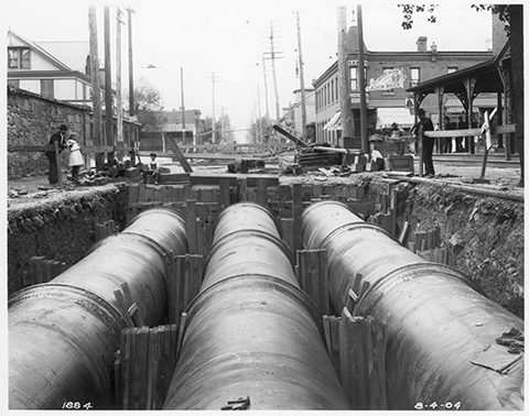
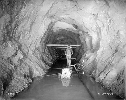
In this week's throwback post, we look at a photo from the Philadelphia Water archives taken on October 24, 1903.

While a bit eerie—14 people died during the multiyear construction of the project pictured—this photo does give you a real sense of appreciation for the scale of water infrastructure beneath our feet and the herculean effort and sacrifice made by the generations before us to make sure their kids (and all of us) could have a future with clean, safe drinking water.

In this image, streams of groundwater entered the Torresdale Conduit as it was blasted out of bedrock, hampering construction. This worker used a hand-operated pump to remove the excess water. The conduit took two and a half years to complete, and had a capacity of 300 million gallons per day.

Still in use today, the Torresdale Conduit was built along the Delaware River waterfront in the first decade of the 20th century. It carries filtered water from the Torresdale Filters (now the Baxter Water Treatment Plant) to the Lardner’s Point Pumping Station, which pumps the water into the city’s system of distribution pipes. When they were completed, both the filter plant (covering about 75 acres) and the pumping station (with a capacity of 200 million gallons a day) were each the largest of their kind in the world.

In his 1987 book Typhoid and the Politics of Public Health in Nineteenth-century Philadelphia, Michael P. McCarthy wrote that the project was popular because the engineers saved about $2 million by using brick instead of cast iron. But there was also, apparently, some civic pride:  "... the conduit was quite popular because, in addition to the savings involved, it was a sophisticated project that gave the city a good deal of favorable publicity."

The conduit is about 2.5 miles long and about 10.5 feet in diameter. Constructed of bricks and mortar, it lies about 100 feet underground and is still an integral part of our water distribution system.

For more information on the history of the city’s water filtration system, check out the work of historian Adam Levine by clicking here.

Syndicate content