NOTICE: PhillyWatersheds.org has been archived.

The archive will be available at http://archive.phillywatersheds.org for approximately one year (through September 2020). If you use or are responsible for content here that is not yet available elsewhere, please contact the PWD Digital Team.

Watershed History

  • strict warning: Non-static method view::load() should not be called statically in /jet/app/www/default/sites/all/modules/views/views.module on line 906.
  • strict warning: Declaration of views_handler_argument::init() should be compatible with views_handler::init(&$view, $options) in /jet/app/www/default/sites/all/modules/views/handlers/views_handler_argument.inc on line 0.
  • strict warning: Declaration of views_handler_filter::options_validate() should be compatible with views_handler::options_validate($form, &$form_state) in /jet/app/www/default/sites/all/modules/views/handlers/views_handler_filter.inc on line 0.
  • strict warning: Declaration of views_handler_filter::options_submit() should be compatible with views_handler::options_submit($form, &$form_state) in /jet/app/www/default/sites/all/modules/views/handlers/views_handler_filter.inc on line 0.
  • strict warning: Declaration of views_handler_filter_node_status::operator_form() should be compatible with views_handler_filter::operator_form(&$form, &$form_state) in /jet/app/www/default/sites/all/modules/views/modules/node/views_handler_filter_node_status.inc on line 0.
  • strict warning: Non-static method view::load() should not be called statically in /jet/app/www/default/sites/all/modules/views/views.module on line 906.
  • strict warning: Declaration of views_plugin_style_default::options() should be compatible with views_object::options() in /jet/app/www/default/sites/all/modules/views/plugins/views_plugin_style_default.inc on line 0.
  • strict warning: Declaration of views_plugin_row::options_validate() should be compatible with views_plugin::options_validate(&$form, &$form_state) in /jet/app/www/default/sites/all/modules/views/plugins/views_plugin_row.inc on line 0.
  • strict warning: Declaration of views_plugin_row::options_submit() should be compatible with views_plugin::options_submit(&$form, &$form_state) in /jet/app/www/default/sites/all/modules/views/plugins/views_plugin_row.inc on line 0.

From the Archives: Cutting a 48-inch cast iron pipe, May 16, 1905

PWD Catalogue No. 1986.002.1902


The distribution system put in place to carry Philadelphia’s filtered water supply to every neighborhood in the City, built along with the filter plants in the first decade of the 20th century, included miles of massive pipes this size. This photo shows how such a pipe was cut to the length needed. The steam engine on the right is transmitting power, via the gears and chain, to draw the blade around the pipe. As the blade goes around, the workmen tighten the blade so it cuts deeper and deeper until it cuts through the pipe.


The grinning child in the background may belong to one of the workmen, or to the photographer, or he simply could have been hiding in the pipe until the photographer said “Cheese!” and then popped his head out so he could be in the picture—something we now call “photo-bombing.” He was certainly not the first or the last child to do this, as a number of photos in the PWD Historical collection show, including this one from 1907. 

From the Archives: Work gang in the Torresdale Conduit, December 18th, 1906

PWD Catalogue No. 1986.002.2546


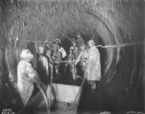
This group of workmen filling a crack in the Torresdale Conduit. They are using slurry of concrete, sometimes called grout, which is being pumped into a crack from the metal basin in the foreground through the nozzle held by the man in the background.


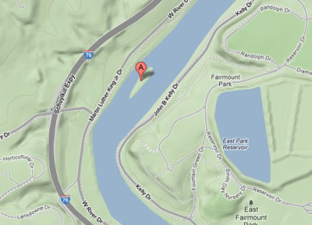
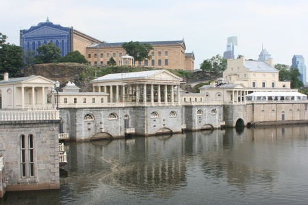
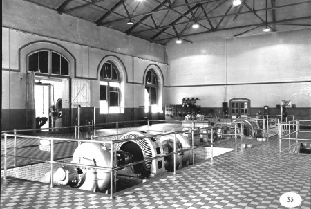
The Torresdale Conduit was built along the Delaware River front in the first decade of the 20th century. It carries filtered water from the Torresdale Filters (now the Baxter Water Treatment Plant) to the Lardner’s Point Pumping Station, which pumps the water into the city’s system of distribution pipes. When they were completed, both the filter plant (covering about 75 acres) and the pumping station (with a capacity of 200 million gallons a day) were each the largest of its kind in the world.


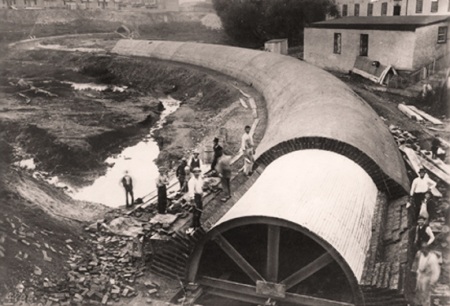
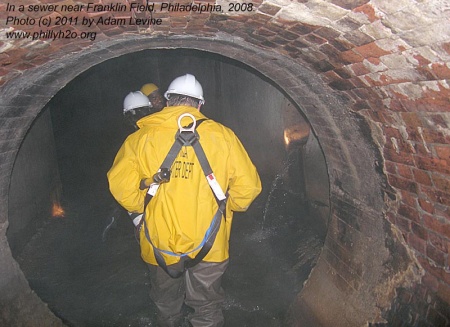
The conduit is about 2.5 miles long and about 10.5 feet in diameter. Constructed of bricks and mortar, it lies about 100 feet underground, and was built completely “in tunnel”, like an underground mining operation, rather than in an open excavation from the surface. To do this, eleven shafts were built along the length of the conduit, connecting the surface with the work area underground. As the construction progressed, excavated material was raised up and removed through these shafts, and construction material was lowered down.


Fourteen people died in the construction of this pipeline, which is still in use and an integral part of the City’s water distribution system.


For more information on the history of the city’s water filtration system, click here.

PWD Answers: What's on the Mysterious Island in the Middle of the Schuykill?

The Philly Watersheds Blog would like to take a siesta from the incessant posting of spokesdog photos to direct your attention toward a recent post on City Paper's Naked City blog. Writer Isaiah Thompson asks PWD's Chris Crockett and Adam Levine: What's the story behind the little island in the middle of the Schuylkill?

Peter's Island, as the little mound turns out to be named (even on Google Maps), has left a surprisingly faint trail in Philly history, considering how long it's been there. Illustrations of it date back at least to the early 1800s (in them, it looks considerably less ominous than it does now). By the mid-20th century, the island had actually ceased to be an island at all, according to Adam Levine, a historical consultant for the Philadelphia Water Department who runs the website PhillyH2O.org. A mountain of sludge — the remnants, Levine says, of a century of coal mining that had washed its way to Philly — had simply extended the river's western bank all the way to the island. It remained a peninsula until some time in the 1950s, when the western channel was dredged back into existence, and the sludge pumped 11 miles southwest to create land in Eastwick, near the airport.

Thompson also discovers firsthand the large population of xenophobic geese living on the island. Check out the whole story  here.

Life, Death and Rebirth of the Schuylkill River

In the 19th century, Philadelphia made a valiant—albeit futile—attempt to implement land management practices to protect its drinking water quality. Join us on Thursday, February 16  from 5:30 to 7:30 p.m. at the Fairmount Water Works Interpretive Center for a discussion of the historical and environmental issues facing the Schuylkill River and Philadelphia's water supply. Ed Grusheski, retired Philadelphia Water Department employee, will share his knowledge and insights about the river that flows outside (and sometimes inside) the Interpretive Center.

Channel Discovery: Philly's Hidden And Forgotten Waterways


Mill Creek Sewer between 47th and Haverford

As you walk on many of Philadelphia's sidewalks, beneath your feet is a hidden world of streams that once crisscrossed the city. Join PWD historian Adam Levine on Thursday, Feb. 16 from 6:30 - 8:30 p.m. at the Temple Gallery at the Tyler School of Art for a fascinating illustrated lecture including rare artwork and artifacts that uncover part of Philadelphia's history few people ever think about—the drastic changes made in the city's landscape since its founding in 1682.

Levine has been digging into the history of the city's sewers and drainage systems since 1998, and his talk will focus on the systematic obliteration of hundreds of miles of surface streams. Buried deep underground in pipes as large as 20 feet in diameter, these former streams became main drainage arteries in the city's 3,000-mile sewer system. These massive alterations to the landscape have had environmental repercussions that are still being felt today. This lecture is guaranteed to reveal a side of Philadelphia you have never seen and change the way you think about our sprawling urban environment.

This event is free, but you must register to reserve your seat.

Watershed History: Philadelphia Filtration

2012 marks the bicentennial of the opening of the Fairmount Water Works, Philadelphia's claim to fame as the first large American city to provide safe water to its residents. Join us at the Fairmount Water Works Interpretive Center on Thursday, January 19 from 5:30 to 7:30 p.m. for a presentation on the history of water filtration in Philadelphia. PWD's Adam Levine and C. Drew Brown will use historical imagery to detail how filtration made the polluted waters of 18th-century Philadelphia safe to drink.

Update: From Creek To Sewer Lecture Postponed

Tonight's scheduled lecture has been postponed. Rescheduled date will be announced soon.


As you walk on many of Philadelphia’s sidewalks, beneath your feet is a hidden world of streams that once crisscrossed the city. Join us tomorrow night, Tuesday September 27 at 7:00 p.m. at the Meadowood Retirement Community in Worcester for a free, fascinating illustrated lecture that will uncover part of Philadelphia’s history that few people ever think about: the drastic changes made in Philadelphia’s landscape since its founding in 1682. Historian and archivist Adam Levine (pictured sewer-spelunking, above) has been digging into the history of the city’s sewers and drainage systems since 1998, and his talk will focus on the systematic obliteration of hundreds of miles of surface streams. Buried deep underground in pipes as large as 20 feet in diameter, these former streams—some of which had watersheds that covered thousands of acres—became main drainage arteries in the city’s 3,000-mile sewer system. These massive alterations to the landscape, undertaken over two centuries, have environmental repercussions that are still being felt today. This lecture is guaranteed to reveal a side of the Philadelphia you have never seen, and change the way you think about cities in general.

There Used to Be An Aquarium at the Fairmount Water Works?


Image: Library of Congress

It's true—Philadelphia had one of the largest and most technologically advanced aquariums in the country. Opened in 1911, the Fairmount Aquarium exhibited local freshwater fishes, amphibians, reptiles, seals and sea lions. Join us at the Fairmount Water Works Interpretive Center on Wednesday, September 21 from 5:30 to 7:30 p.m. as guest speaker Samantha Muka (a PhD candidate in the History of Science Department at the University of Pennsylvania) presents From Turbines to Tanks: The Early Days of the Philadelphia Aquarium at the Fairmount Water Works. The presentation draws from local archives, including photos and videos. The event is free—please RSVP by calling 215-685-0723.

Watershed History: South Philadelphia Tidal Marshes

From the desk of Philadelphia Water Department historical consultant Adam Levine:


Image: Temple University Urban Archives

Most people don't realize that much of the lower part of South Philadelphia was once covered by tidal marshes. South Philly was once called “the Neck” because of the shape of the area (look at a map of the city if you cannot picture this easily), and about six square miles of the neighborhood were covered by marshland laced by both natural tidal creeks and man-made drainage canals.

Besides the canals, miles of dikes were built along both the Delaware and Schuylkill riverfronts, beginning in the 18th century. The dikes kept the land out of reach of the high tide, which allowed it to be used for growing hay and other crops well into the 20th century. Millions of cubic yards of fill were used to raise these lowlands, a process that began in the early 20th century and continued for more than 50 years. Material used for the filling came from various sources, including city refuse, dredge spoils from the Delaware and Schuylkill river dredging projects, and material excavated during construction of the Broad Street subway.

In 1920, Christopher Morley painted a vivid verbal picture of this area in his wonderful essay. The accompanying map and photographs are used by permission of Temple University Libraries Urban Archives Bulletin Collection.

Click here for a 1927 image from the Evening Bulletin with photos and captions of Stonehouse Lane and the canals that once wound below Oregon Avenue.

Watershed History: Roxborough Pumping Station Demolition

From the desk of Philadelphia Water Department historical consultant Adam Levine:


Roxborough Pumping Station, 1961


Roxborough Pumping Station, 2010

As of July 7, the old Roxborough Pumping Station was in the process of being demolished. This piece of the city’s water supply history had been out of commission since 1962, and as shown in the color photos (taken by city photographer Richard Goldey in December 2010), it had lately become a graffiti-covered ruin. The black and white photos were taken in 1961, just before the plant was taken out of service. The high roofline once accommodated huge coal-fired steam pumping engines, which were replaced by the much smaller but much more efficient electric pumps shown in the 1961 photo below. Even in its derelict state, the former grandeur of this public building, designed to be both functional as well as beautiful, is still apparent. 


Interior of Roxborough Pumping Station, 1961


Interior of Roxborough Pumping Station, 2010

Related: Read our recent post on the Roxborough Water Works.

Syndicate content